Carte

Utiliser cette image
Puis-je réutiliser cette image sans autorisation? Oui
Les images sur le portail de la collection d’Ingenium ont la licence Creative Commons suivante :
Copyright Ingenium / CC BY-NC-ND (Attribution-NonCommercial 4.0 International (CC BY-NC 4.0)
ATTRIBUER CETTE IMAGE
Ingenium,
2018.0113.001
Permalien:
Ingenium diffuse cette image sous le cadre de licence Creative Commons et encourage son téléchargement et sa réutilisation à des fins non commerciales. Veuillez mentionner Ingenium et citer le numéro de l’artefact.
TÉLÉCHARGER L’IMAGEACHETER CETTE IMAGE
Cette image peut être utilisée gratuitement pour des fins non commerciales.
Pour un usage commercial, veuillez consulter nos frais de reproduction et communiquer avec nous pour acheter l’image.
- TYPE D’OBJET
- marine/navigational/Rebbelith
- DATE
- 1950
- NUMÉRO DE L’ARTEFACT
- 2018.0113.001
- FABRICANT
- Inconnu
- MODÈLE
- Inconnu
- EMPLACEMENT
- Inconnu
Plus d’information
Renseignements généraux
- Nº de série
- S/O
- Nº de partie
- 1
- Nombre total de parties
- 1
- Ou
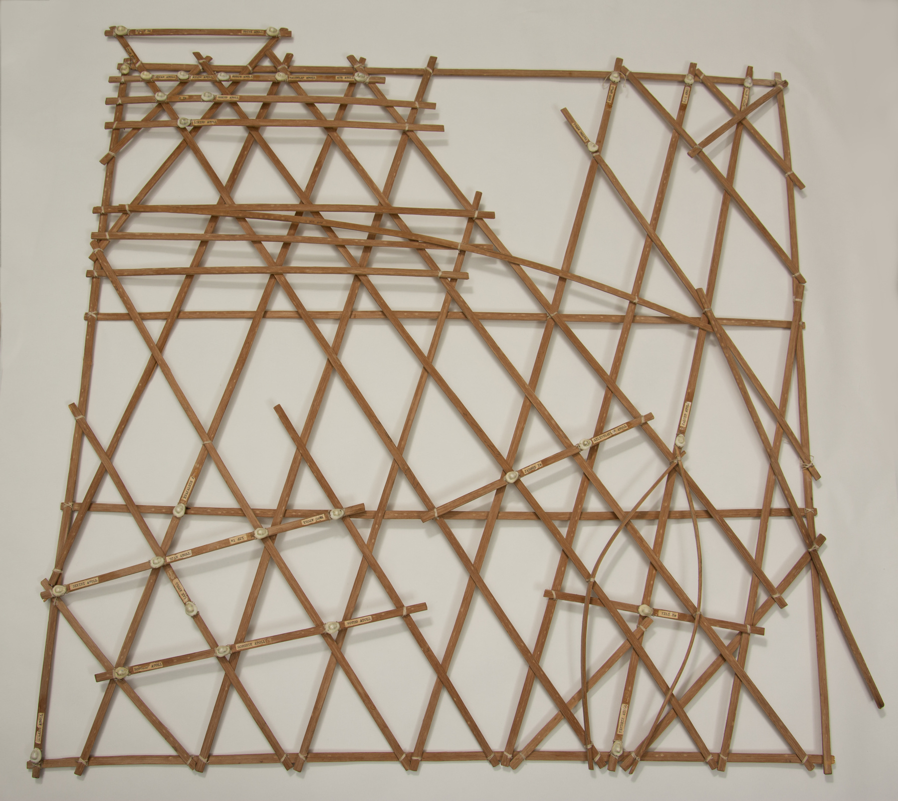
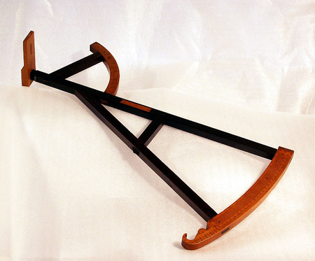
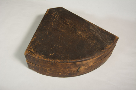
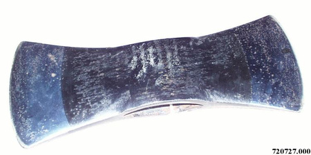
- Stick chart
- Brevets
- S/O
- Description générale
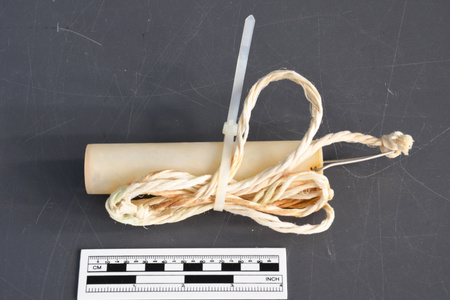
- Wood chart with fibre twine, shell island markers and paper labels
Dimensions
Remarque : Cette information reflète la taille générale pour l’entreposage et ne représente pas nécessairement les véritables dimensions de l’objet.
- Longueur
- 89,0 cm
- Largeur
- 88,0 cm
- Hauteur
- 3,5 cm
- Épaisseur
- S/O
- Poids
- S/O
- Diamètre
- S/O
- Volume
- S/O
Lexique
- Groupe
- Transports maritimes
- Catégorie
- Instruments et équipement de navigation
- Sous-catégorie
- S/O
Fabricant
- Ou
- Inconnu
- Pays
- Inconnu
- État/province
- Inconnu
- Ville
- Inconnu
Contexte
- Pays
- Inconnu
- État/province
- Inconnu
- Période
- Inconnu
- Canada
-
Marshall Islands Stick Charts represent many fundamental aspects of ocean knowledge, and geographically, a significant dimension of the scientific culture and heritage in the Pacific region; In addition, the charts represent common aspects of way finding in other regions. For example, the skills and techniques described by David Lewis in "We, The Navigators" resemble the navigational and wayfinding skills employed by Indigenous peoples in Canada’s north. Although applied often in a frozen context, the Inuit have developed a sophisticated and holistic navigation system based on observations and vocabulary for wind, snowdrift patterns, stars, clouds, vegetation, sea currents and landmarks. (MacDonald, Arctic Sky, pp. 160-191). - Fonction
-
Stick Charts were mnemonic and instructional devices used to teach navigation based on careful observation of complex swell patterns and ocean movements, in conjunction with other navigational indictors such as observation of stars, sun, seasonal wind changes, and bird migration. (From Acquisition Proposal, see Ref. 1) - Technique
-
Marshall Island Stick Charts are made of palm sticks assembled to represent the prevailing ocean movements around an islands, small group of islands or the large Marshall Chain. Intersections often represent islands, and larger intersections and islands represented with sewn Cowrie shells. There are three types of Marshallese charts, mattang, meddo, and rebbilib. The mattang is “instructional and mnemonic,” the meddo “shows swells patterns in relation to a few islands,” and the rebbilib covers a larger part of the archipelago with a more geographic focus on the islands among swell patterns. The latter charts, with their geographic representation, appear to be influenced by Western traditions. (Lewis, 1994, pp 245-250). (From Acquisition Proposal, see Ref. 1) - Notes sur la région
-
Inconnu
Détails
- Marques
- On the various labels on the chart, in the top proper right quadrant: "M[?]J[?]T Is"/ "UTRIK ATOLL"/ "OKAK ATOLL"/ "BIKAR ATOLL"/ "AILUK ATOLL"/ "WOTJE ATOLL"/ "MALOELAP ATOLL"/ "AUR ATOLL"/ "[?]O Is"/ "ERKUP ATOLL"/ "LIKIEP ATOLL"/ In the top proper left quatrant: "ARNO ATOLL"/ "MILI ATOLL"/ "[M[ADRIKE[I]K ATOLL"/ "MAJURO ATOLL"/ In the lower proper left quadrant: "JABWOT Is"/ "AILINGLAPLAP ATOLL"/ "JALUIT ATOLL"/ "KILI Is"/ "NAMDRIK ATOLL"/ In the lower proper right quadrant: "KWAJALEIN A"/ "BIKINI ATOLL"/ "UJAE ATOLL"/ "LIP Is"/ "NAMO ATOLL"/ LAE ATOLL"/ "UJLANG ATOLL"/ RONG[L]AP ATOLL"/ "RONGRIK ATOLL"/ "WOTHO ATOLL"
- Manque
- Appears complete
- Fini
- Light brown wood sticks lashed together in an irregular lattice formation with off-white coloured twine. Placed at different spots on the lattice are off-white shells attached to the wood next to beige coloured paper labels with black printing.
- Décoration
- S/O
FAIRE RÉFÉRENCE À CET OBJET
Si vous souhaitez publier de l’information sur cet objet de collection, veuillez indiquer ce qui suit :
Fabricant inconnu, Carte, vers 1950, Numéro de l'artefact 2018.0113, Ingenium - Musées des sciences et de l'innovation du Canada, http://collection.ingenium.ca/fr/id/2018.0113.001/
RÉTROACTION
Envoyer une question ou un commentaire sur cet artefact.
Plus comme ceci


2018.0113.001