Photographie
Utiliser cette image
Puis-je réutiliser cette image sans autorisation? Oui
Les images sur le portail de la collection d’Ingenium ont la licence Creative Commons suivante :
Copyright Ingenium / CC BY-NC-ND (Attribution-NonCommercial 4.0 International (CC BY-NC 4.0)
ATTRIBUER CETTE IMAGE
Ingenium,
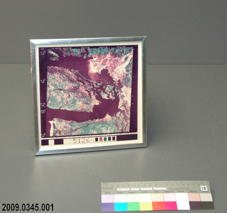
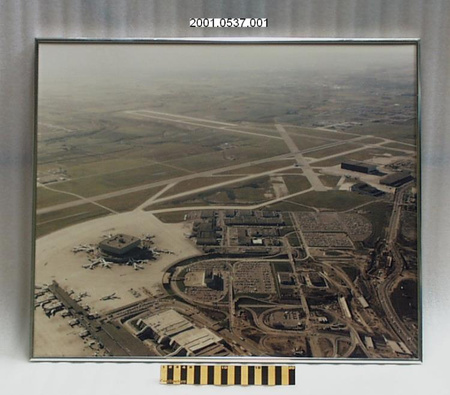
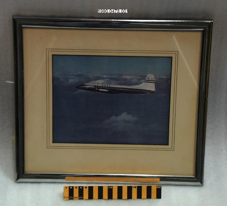
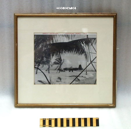
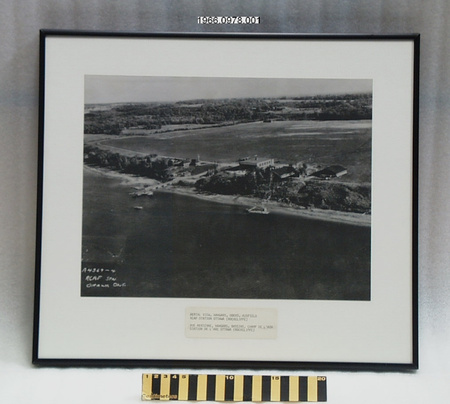
2009.0345.001
Permalien:
Ingenium diffuse cette image sous le cadre de licence Creative Commons et encourage son téléchargement et sa réutilisation à des fins non commerciales. Veuillez mentionner Ingenium et citer le numéro de l’artefact.
TÉLÉCHARGER L’IMAGEACHETER CETTE IMAGE
Cette image peut être utilisée gratuitement pour des fins non commerciales.
Pour un usage commercial, veuillez consulter nos frais de reproduction et communiquer avec nous pour acheter l’image.
- TYPE D’OBJET
- aerial/satellite
- DATE
- 1975
- NUMÉRO DE L’ARTEFACT
- 2009.0345.001
- FABRICANT
- Landsat satellite
- MODÈLE
- Inconnu
- EMPLACEMENT
- Inconnu
Plus d’information
Renseignements généraux
- Nº de série
- S/O
- Nº de partie
- 1
- Nombre total de parties
- 1
- Ou
- First Digitally Processed Image
- Brevets
- S/O
- Description générale
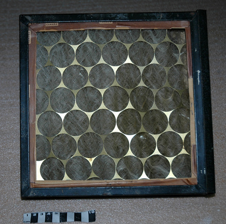
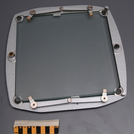
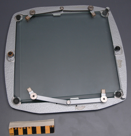
- A synthetic silver frame with carboard and a paper backing, a clear synthetic covering the image and a digital image printed on paper/carboard[?]
Dimensions
Remarque : Cette information reflète la taille générale pour l’entreposage et ne représente pas nécessairement les véritables dimensions de l’objet.
- Longueur
- 24,0 cm
- Largeur
- 24,0 cm
- Hauteur
- 1,0 cm
- Épaisseur
- S/O
- Poids
- S/O
- Diamètre
- S/O
- Volume
- S/O
Lexique
- Groupe
- Technologie de l'espace
- Catégorie
- Observation de la terre
- Sous-catégorie
- S/O
Fabricant
- Ou
- Landsat
- Pays
- Inconnu
- État/province
- Inconnu
- Ville
- Inconnu
Contexte
- Pays
- Canada
- État/province
- Ontario
- Période
- Inconnu
- Canada
-
This is the first all digitally processed image, using data from a Landsat satellite. This is of the south end of Vancouver Island and the strait across the Gulf Islands to Vancouver, BC. - Fonction
-
It shows the physical characteristic of the Earth, a seen by a satellite. - Technique
-
Previously aerial images were taken using airplanes or balloons. This one is generated from data gathered from the Landsat satellite. - Notes sur la région
-
Inconnu
Détails
- Marques
- Mfr's:"12AUG73/N48 30 W123 09 OY 022 SUN EL00 AZ000 196 05369 T I N P 1L E 1385 18365 08 JUL 75/5126-[blank]56[blank][blank]/-AA N 49=30 \W123-30\W122-30 \W122-00/N 39-40/N 49-00/N 48-30/N 48-00+."
- Manque
- Nothing is missing.
- Fini
- A synthetic silver frame with carboard and paper backing and the digital image is printed on paper/carboard.
- Décoration
- None
FAIRE RÉFÉRENCE À CET OBJET
Si vous souhaitez publier de l’information sur cet objet de collection, veuillez indiquer ce qui suit :
Landsat satellite, Photographie, vers 1975, Numéro de l'artefact 2009.0345, Ingenium - Musées des sciences et de l'innovation du Canada, http://collection.ingenium.ca/fr/id/2009.0345.001/
RÉTROACTION
Envoyer une question ou un commentaire sur cet artefact.
Plus comme ceci


2009.0345.001
