Calculatrice de distance
Utiliser cette image
Puis-je réutiliser cette image sans autorisation? Oui
Les images sur le portail de la collection d’Ingenium ont la licence Creative Commons suivante :
Copyright Ingenium / CC BY-NC-ND (Attribution-NonCommercial 4.0 International (CC BY-NC 4.0)
ATTRIBUER CETTE IMAGE
Ingenium,
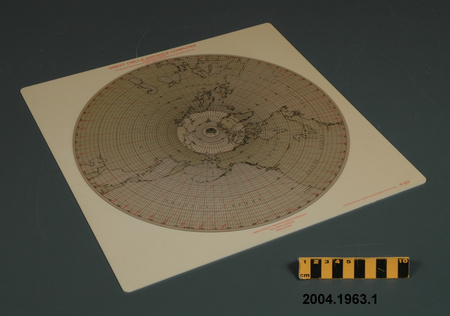
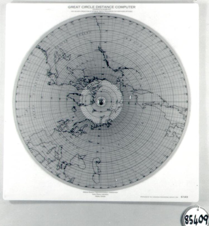
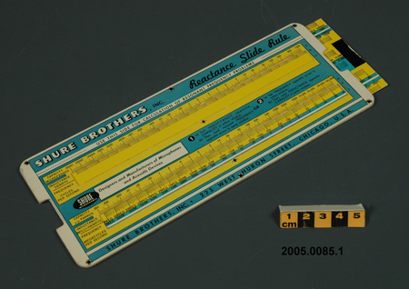
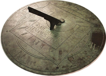
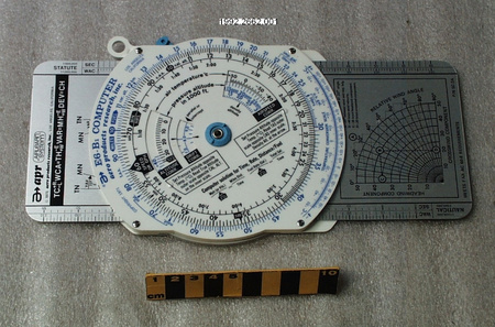
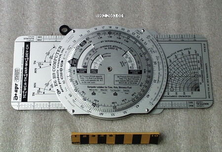
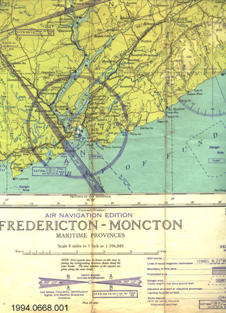
2004.1963.001
Permalien:
Ingenium diffuse cette image sous le cadre de licence Creative Commons et encourage son téléchargement et sa réutilisation à des fins non commerciales. Veuillez mentionner Ingenium et citer le numéro de l’artefact.
TÉLÉCHARGER L’IMAGEACHETER CETTE IMAGE
Cette image peut être utilisée gratuitement pour des fins non commerciales.
Pour un usage commercial, veuillez consulter nos frais de reproduction et communiquer avec nous pour acheter l’image.
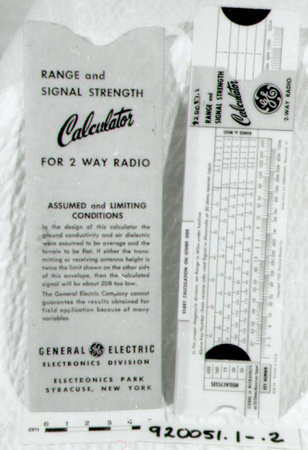
- TYPE D’OBJET
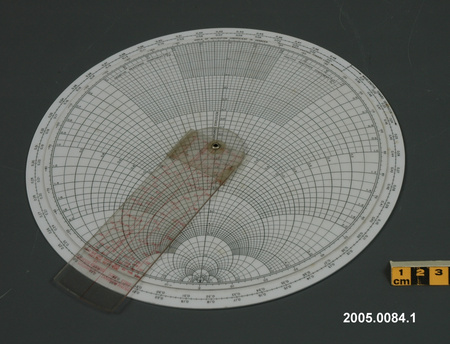
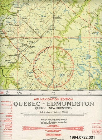
- HF radio frequency prediction
- DATE
- 1956
- NUMÉRO DE L’ARTEFACT
- 2004.1963.001
- FABRICANT
- Canadian Hydrographic Service
- MODÈLE
- Great Circle Distance Calculator S-143
- EMPLACEMENT
- Canada
Plus d’information
Renseignements généraux
- Nº de série
- S/O
- Nº de partie
- 1
- Nombre total de parties
- 1
- Ou
- S/O
- Brevets
- S/O
- Description générale
- synthetic base and disk/ metal spindle
Dimensions
Remarque : Cette information reflète la taille générale pour l’entreposage et ne représente pas nécessairement les véritables dimensions de l’objet.
- Longueur
- 34,7 cm
- Largeur
- 34,3 cm
- Hauteur
- S/O
- Épaisseur
- S/O
- Poids
- S/O
- Diamètre
- S/O
- Volume
- S/O
Lexique
- Groupe
- Mathématiques
- Catégorie
- Dispositifs à calculer
- Sous-catégorie
- S/O
Fabricant
- Ou
- Hydrographic
- Pays
- Canada
- État/province
- Inconnu
- Ville
- Inconnu
Contexte
- Pays
- Canada
- État/province
- Inconnu
- Période
- mid 1950's +
- Canada
-
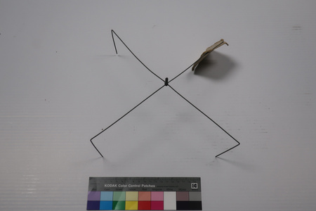
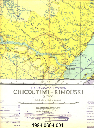
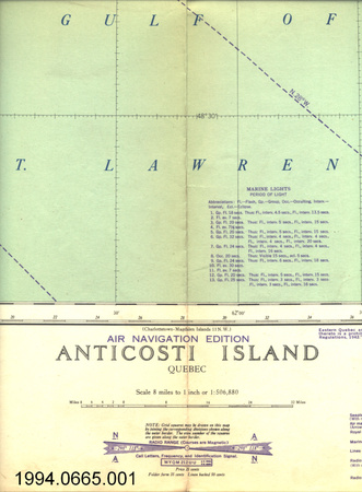
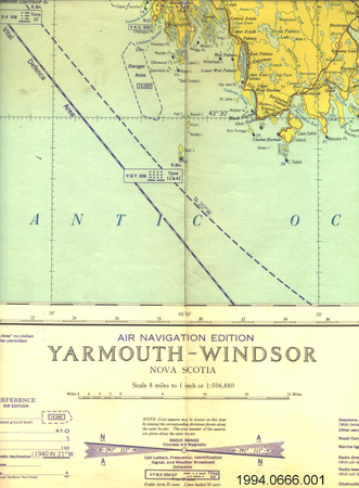
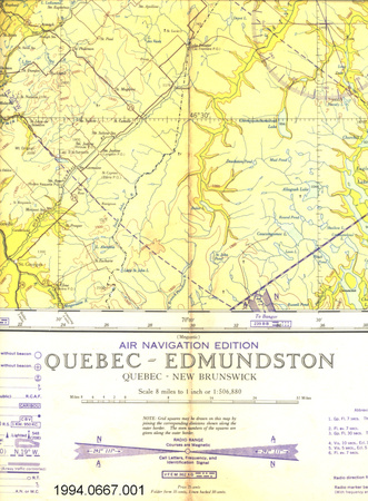
This calculator was produced by the Canadian Hydrographic Service in 1956 for the Defence Research Telecommunications Establishment, Radio Physics Laboratory, Ottawa, Canada. It was probably used in conjunction with Boulder Colorado reports on the behaviour of aurora. It was acquired by the donor while he was with DRTE at Shirley's Bay. This system for predicting the number of frequencies was developed within the Defense Research Board for use by DND personnel to improve radio communications within Canada & to NATO bases abroad. It was later made available for civilian use. DRTE was the Defence Research Telecommunications Establishment of the Defence Research Board of the Department of National Defence. Since 1883, the Canadian Hydrographic Service (CHS) has studied Canada's oceans, lakes and rivers to ensure their safe, sustainable and navigable use. The service was established in 1883 to survey and chart the navigable waters of Georgian Bay and Lake Huron and eventually all of Canada's inland waterways and coastal regions. In 1928 the name Canadian Hydrographic Service was officially adopted. The demand for Arctic surveys reached a peak during 1954-57 when the Distant Early Warning (DEW line) system was built across Canada with many stations in the Canadian Arctic. - Fonction
-
A device used in the prediction of optimum traffic frequencies for northern latitudes. It showed where the great circle distance intersected with the auroral zone. The calculator was used to determine the length of a radio circuit which was then used with the tables to calculate the maximum useable frequency for that circuit as a function of time of day, month, and for a given sunspot number. - Technique
-
Any tool which gives answers quickly, accurately and without extensive calculating is helpful. This system covered high latitudes which was the Canadian requirement compared with the American system which did not provide coverage of the north. The system was based on statistical averaging of data taken by ionospheres around the world. The system was later computerized & used for many years. A great circle is a circle containing a segment that represents the shortest distance two given points on the earth's surface. The great circle distance is the length of the shorter arc of the great circle joining the two points [Ref. 1]. - Notes sur la région
-
Inconnu
Détails
- Marques
- red lettering on base reads 'GREAT CIRCLE DISTANCE CALCULATOR/ DISTANCES IN KILOMETRES/ FOR USE WITH PREDICTION OF OPTIMUM TRAFFIC FREQUENCIES FOR NORTHERN LATITUDES/ R.P.I REPORT No. 1-1-3'; 'Defence Research Telecommunications Establishment/ Radio Physics Laboratory/ Ottawa, Canada'; and 'PRODUCED BY THE CANADIAN HYDROGRAPHIC SERVICE 1956 S-143'/ black lettering, numbers and markings on disk map
- Manque
- appears complete
- Fini
- white base with colourless transparent disk and metallic spindle
- Décoration
- S/O
FAIRE RÉFÉRENCE À CET OBJET
Si vous souhaitez publier de l’information sur cet objet de collection, veuillez indiquer ce qui suit :
Canadian Hydrographic Service, Calculatrice de distance, 1956, Numéro de l'artefact 2004.1963, Ingenium - Musées des sciences et de l'innovation du Canada, http://collection.ingenium.ca/fr/id/2004.1963.001/
RÉTROACTION
Envoyer une question ou un commentaire sur cet artefact.
Plus comme ceci


2004.1963.001
