Photograph
Use this image
Can I reuse this image without permission? Yes
Object images on the Ingenium Collection’s portal have the following Creative Commons license:
Copyright Ingenium / CC BY-NC-ND (Attribution-NonCommercial 4.0 International (CC BY-NC 4.0)
ATTRIBUTE THIS IMAGE
Ingenium,
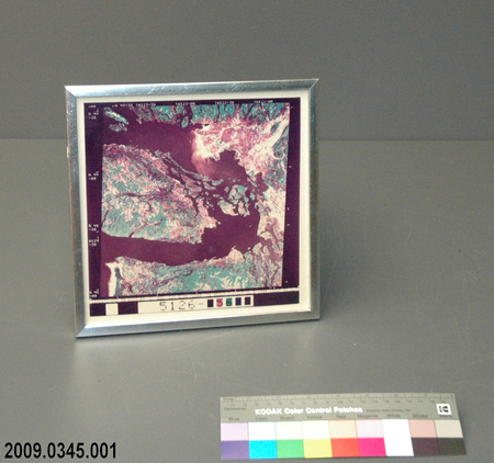
2009.0345.001
Permalink:
Ingenium is releasing this image under the Creative Commons licensing framework, and encourages downloading and reuse for non-commercial purposes. Please acknowledge Ingenium and cite the artifact number.
DOWNLOAD IMAGEPURCHASE THIS IMAGE
This image is free for non-commercial use.
For commercial use, please consult our Reproduction Fees and contact us to purchase the image.
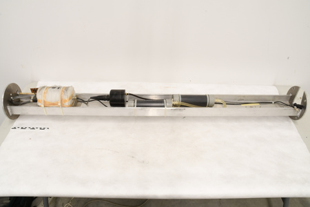
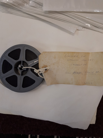
- OBJECT TYPE
- aerial/satellite
- DATE
- 1975
- ARTIFACT NUMBER
- 2009.0345.001
- MANUFACTURER
- Landsat satellite
- MODEL
- Unknown
- LOCATION
- Unknown
More Information
General Information
- Serial #
- N/A
- Part Number
- 1
- Total Parts
- 1
- AKA
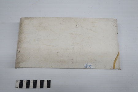
- First Digitally Processed Image
- Patents
- N/A
- General Description
- A synthetic silver frame with carboard and a paper backing, a clear synthetic covering the image and a digital image printed on paper/carboard[?]
Dimensions
Note: These reflect the general size for storage and are not necessarily representative of the object's true dimensions.
- Length
- 24.0 cm
- Width
- 24.0 cm
- Height
- 1.0 cm
- Thickness
- N/A
- Weight
- N/A
- Diameter
- N/A
- Volume
- N/A
Lexicon
- Group
- Space Technology
- Category
- Earth observation
- Sub-Category
- N/A
Manufacturer
- AKA
- Landsat
- Country
- Unknown
- State/Province
- Unknown
- City
- Unknown
Context
- Country
- Canada
- State/Province
- Ontario
- Period
- Unknown
- Canada
-
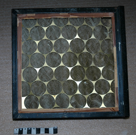
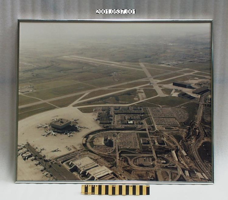
This is the first all digitally processed image, using data from a Landsat satellite. This is of the south end of Vancouver Island and the strait across the Gulf Islands to Vancouver, BC. - Function
-
It shows the physical characteristic of the Earth, a seen by a satellite. - Technical
-
Previously aerial images were taken using airplanes or balloons. This one is generated from data gathered from the Landsat satellite. - Area Notes
-
Unknown
Details
- Markings
- Mfr's:"12AUG73/N48 30 W123 09 OY 022 SUN EL00 AZ000 196 05369 T I N P 1L E 1385 18365 08 JUL 75/5126-[blank]56[blank][blank]/-AA N 49=30 \W123-30\W122-30 \W122-00/N 39-40/N 49-00/N 48-30/N 48-00+."
- Missing
- Nothing is missing.
- Finish
- A synthetic silver frame with carboard and paper backing and the digital image is printed on paper/carboard.
- Decoration
- None
CITE THIS OBJECT
If you choose to share our information about this collection object, please cite:
Landsat satellite, Photograph, circa 1975, Artifact no. 2009.0345, Ingenium – Canada’s Museums of Science and Innovation, http://collection.ingenium.ca/en/id/2009.0345.001/
FEEDBACK
Submit a question or comment about this artifact.
More Like This


2009.0345.001
